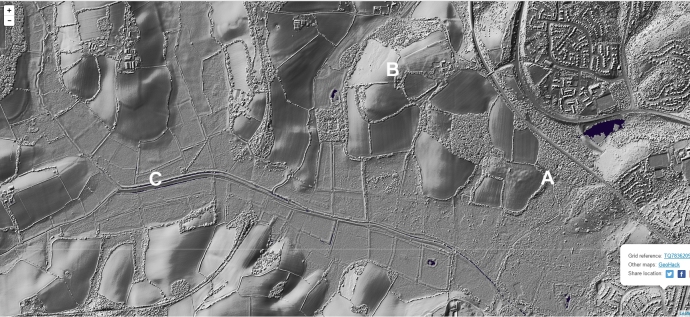
The original of this map can be found here.
A) shows clearly defined defense type structure at the proposed site of the Saxon port of Hastings pre-1066. Circular defensive ditch type layout in Five Acre field next to Redgeland Wood where the Chronicle of Battle Abbey states “they camped at Hedgeland” but actually the R may have been misread on the original as no-one knew at the time where Redgeland was. Other Lidar previously shown on this site shows another circular structure within Redgeland Wood where access to the port would have been found before the estuary silted up in 1290s. Hastings Port was the largest of the Cinque Ports prior to its demise. According to the accounts at the time at least 500 ships landed at that port according to Wace – here you can see exactly where it was.
B) is the hill above the port area (now Wilting Manor House- home of the first Norman Sheriffs of Hastings, Engleran and his brother). The Carmen states the Normans “restored the forts which had stood there formerly” (or depending upon your branch of Latin – the “defensive structures” that were there.) This anathema is impossible to explain by Pevensey or Hastings Castle since Hastings Castle was not there and Pevensey had only one defense that was not reinstated. This was a primary reason for the dismissal of the Carmen in the nineteenth century by historians, only to have it’s rightful authority restored on academic grounds by Elizabeth Van Houtts in the last thirty years, whilst I have been doing this work. We can now see the Carmen was right and so was Ms Houtts. Here in this image we see the Saxon Defense by the shore and to the right of the B the original structure of what was called Chapel Field where Wace records “they set up chapels” on the night of the battle. In chapel field is the clear outline of Hastings Burgh which was destroyed by the Normans prior to the Battle and consequently not included in the Domesday survey. There is no Burgh structure anywhere else and within the outline we see an additional ditch which may predate the construction. However one of the DeScotneys (Lords of the Crowhurst Manor was assigned to stay at the Old Burgh of Wilting according to a document I am still trying to get to see the original. The County Heritage map on the other hand shows Chapel Field was recorded as “possible site of early medieval village”. The archeology shows that the earth from the north side of this field was stacked by someone to level it out. The historical record shows this was under King Alfred’s instructions. Proper evaluation of this Burgh is now required because it represents a major heritage asset which like in other Burgh towns will not only add to the Hastings story but be a valuable tourism asset to the county. It would be good for Hastings to have this heritage asset reinstated.
C) shows a feature in the marsh above the C that looks remarkably like a marsh platform of some sort. It is located right in the new road route so hopefully we will get confirmation of what it is in the course of time. Given the location in an area rich in Bronze Age relics and near the Bronze Age tree we found around 1996 which had the axe cuts in it dated the same time as Stonehenge was being used I would not be surprised to find it connected to Bronze Age activity.
Lastly let me add that there is a massive amount of information on the web that is repeated ad infinitum by people who have not looked at any of the original documents. There is no archaeological evidence to even suggest that the Normans occupied Hastings Old town before 1090 when the Count of Eu moved the castle from the port to its present position and like the Battlefield site the assumption that the port was where the castle now stood (above where the cricket ground used to be). However this theory in the absence of evidence was completely discredited by the archaeological report which Hastings Council kindly produced to show they could build the shopping center there. The Hastings Castle of today that is falling into the sea was built on a headland next to a marsh that was always a marsh, with a shingle bank across its entrance, where Debenhams now resides. Taking all this into account the conclusion points to activity in the Crowhurst Valley where Hastings town pre 1066 was probably in existence within the so called “Saxon Doug-nut” and Burgh. It also explains why the Battle became known as the battle of Hastings – because it was in the same valley as the port and town of Hastings. Its time someone sensible in the world of history and archeology came down and had a look.


 Hastings Link Road Video here

